

Geo-RelNAV
Relative navigation between two or more moving platforms
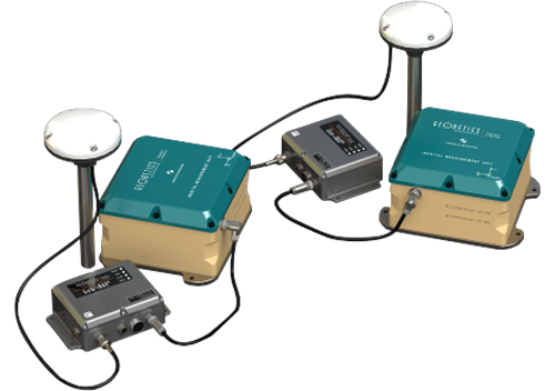
A UNIQUE GPS / IMU BASED NAVIGATION SYSTEM
The relative navigation information computed by Geo-RelNAV includes relative position, relative velocity (closure rate), and relative orientation. The Geo-RelNAV system works by transmitting data, through a data link, from the follower units to the leader unit where it is used in the relative computations. Geo-RelNAV provides a variety of ways to connect to a data link including via RS-232 and Ethernet and does not specify a data link type (i.e., TDMA) or operating frequency.
Applications
Probe & Drogue
Boom and Receptacle
Shipboard Landing
Benefits
Minimized sensor size and weight to meet payload restrictions
Available with different grades of IMU’s to support a wide range of application requirements
Aerial refueling applications: Probe- Drogue and Boom system
On-Board data logging of all sensors raw and navigation solution data.
The relative navigation can be provided between one leader and multiple followers
The system can be upgraded to vision-aided navigation for GPS-denied environments
Beside relative data, the system can also provide absolute PNT solutions of leader and multiple followers
Real time navigation and visualization tool for monitoring absolute and relative PNT data on leader and follower units
Additional aiding sensors, such as barometers, Altitude Heading and Refence Systems (AHRS), odometers, etc., can be integrated
Includes GPS antenna and cables
Anti-Jam Antennas are optional
Additional aiding sensors, such as barometers, Altitude Heading and Refence Systems (AHRS), odometers, etc., can also be integrated
VYO Real-Time Navigation Visualization Tool as convenient interface to visualize time, position, attitude and related information (TSPI) streamed data
Specifications
Size / Weight / Power:
33.8 in (3.95×3.05×2.06) / 14.4 oz. / 10 – 30 VDC @ 2 amps
Temperature Range:
Specified: -20°C to +65°C
Operating: -40°C to +70°C
Real-Time Data Output:
Navigation solutions at up-to 125 Hz. available via Ethernet or RS-232
Data Recording/Logging:
Relative navigation solutions, absolute navigation solutions, raw GPS, IMU
Interfaces:
External power connector
TNC GPS antenna connectors
1 Ethernet data port
3 RS-232 serial ports
1PPS output, 4 status LEDs