

Geo-HGGR
GPS/INS-based guidance, navigation and control for ACMI POD life extension, guided munitions, UAVs, range instrumentation, target control systems, helicopters and ground vehicles.
FOR COMBAT TRAINING RANGE INSTRUMENTATION, TARGET CONTROL SYSTEMS
HGGR provides a cost-effective Form, Fit and Function drop-in replacement for the GNP-10 module, offering high-performance GPS/INS-based guidance, navigation and control for applications including legacy ACMI POD life extension, guided munitions, unmanned aerial vehicles, combat training range instrumentation, target control systems, helicopters, and ground vehicles. HGGR is offered in both commercial and SAASM (M-code) variants.
Applications
Training aircraft pods
Range testing
Payload/pod performance monitoring
Data validation
Benefits
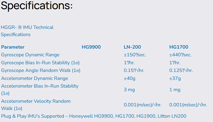
Built-in support for many commonly used IMU’s, including HG1700 and LN-200
(see supported Plug & Play IMUs in the IMU Specifications)
Provides navigation solutions at arbitrary points of interest and in the local navigation frame
(wander azimuth)No singularities passing over geographic South/North poles or crossing over meridians
Flexible mounting and Automatic Attitude Detection to determine wing mount station orientation for naval shipboard landings
Full solution latency compensation
Alternative and complementary navigation systems during GPS-denied or challenged environments
(X-INS aided)Board-level test set capable for ease of maintenance
GNP-10 compatible message format
Complete weight, balance, mass properties
Mil-spec ruggedization, temperature/vibration tolerance